This is an archived article. Click here to return to the blog's home page.
Anatomy of a Clearcut
Entry 11: February 8, 2015
|
SDS Lumber is a timber company operating out of the town of Bingen, Washington. At the end of 2011, it logged 110 acres of land above the Historic Columbia River Highway State Trail in Mosier. The site consists of two parcels, about one third owned by SDS and the remaining two thirds owned by the Warm Springs Tribe. Trees on the site were burned in the 2009 Microwave fire, and a clearcut operation was conducted to salvage the burned timber. The resulting deforested area was an eyesore that appeared seemingly overnight and angered residents, who had no idea it was happening. The site was on land in the Columbia Gorge Scenic Area designated as General Management Area (GMA) Open Space, where timber harvest was thought to be prohibited. The logged area was visible from towns, trails, and the major highways in both Oregon and Washington. The historic highway trail's character was seriously impacted (Figure 1).
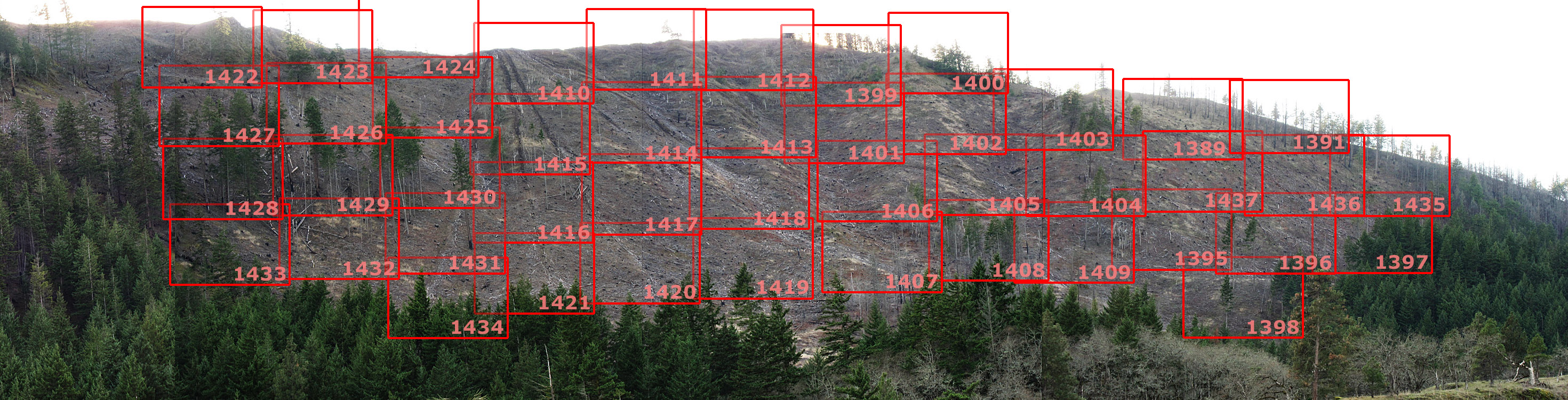
The Columbia Gorge Commission, the agency managing the Scenic Area, declined to take any enforcement action. Fueled by public outrage, a controversy erupted that is unresolved to this day, owing to an unclear legal framework for logging within the Scenic Area that is subject to varying interpretations. Further complicating the issue is that some of the land is tribal land, and therefore outside the Commission's jurisdiction. There are plans to strengthen the Oregon Forest Practices Act (OFPA) in the 2015 legislative session. State Senator Michael Dembrow of Portland and state Representative Ann Lininger of Lake Oswego are involved in the revisions. Oregon's law is more lenient than those in neighboring states. The law is so weak that on January 30, 2015, federal authorities rejected Oregon's plan for reducing nonpoint pollution along the coast, much of it from logging operations. Clearcut Map Key (virtual tour) On March 7, 2014, I conducted a photographic survey of the clearcut that allows a virtual tour of the land in detail. To get started, click on a number or non-overlapping part of a red rectangle below to open the detailed image for the part of the clearcut you wish to view. Once the image opens in the OneDrive viewer, click "View Original" and then click on the image (the mouse pointer will become a magnifying glass) to view it in a browser window at the highest resolution. Note that original images may take some time to download. Below the map key are observations for many frames that highlight areas of interest. Because the key is a panoramic image, scroll your browser window to the right to see all of it. |
Click here to skip observations and read the Conclusion
|
Frame-by-frame Observations In frame 1399, a herd of four deer is browsing in the lower left corner, useful for size reference. Fence wire and posts are visible at the upper left corner at the ridgetop. Deer activity could impact the survival of seedlings. Two deer are at the top left corner of frame 1401. Slightly to left of center, a gully and slopes running toward it show rocky areas where erosion has taken place. Frame 1410 shows the apex of the yarding scars. The ground in the scars is bare, with no topsoil or vegetation present. Some subsoil, charcoal, and large areas of exposed rocks are visible. There is no indication of effort to restore soil or vegetation cover in the scars. Mr. Behling pointed out that the operator hand-dug some water bars to deflect water flowing downhill and these are visible in the frame. Two deer are at the bottom of frame 1412 in the center. Along the ridgetop, four areas of bare soil are noted, from 60 to 260 feet long and roughly 20 feet wide. These could be from limited yarding activity. In frame 1413, five deer are at the top center; two of the deer are also shown in the overlapping portion of frame 1412. Several exposed and eroded rocky areas are present, especially at the lower left corner. The deer are likely the same ones in frame 1399 since the two frames adjoin. At the bottom of the yarding scars in frame 1414 are extensive rocky areas indicative of erosion, rockfall, or soil disturbance. Some yarding scars end in Frame 1416. Eroded, rocky areas are present where the scars end. Seedlings are growing at the bottom edge of frame 1419. They are dense in the areas where present, indicating the growth is natural rather than planted. In frame 1420, there are also some seedlings at the bottom of the frame, and a few higher up. Along the left edge of frame 1422 are a number of burned stumps. A yarding scar with large eroded areas lies to the right of the stumps. A yarding scar is visible along the right edge of frame 1425 with exposed subsoil and some rocky areas. Frame 1426 is steeply sloped and there is very little topsoil. There are significant rocky and eroded areas. In frame 1428, rocky areas inside unlogged forest at the bottom of the clearcut in swales indicate erosion or rockfall since there would be no soil displaced from yarding at that location. See the bottom of the frame, right of center. Frame 1430 shows the middle of a yarding scar. Topsoil in the scar has been scraped away. Along the bottom of the frame are areas of fresh rock from rockfall or erosion, and some areas of older rock that have moss covering. Frame 1431 continues the yarding scar from 1430. Again, the topsoil is poor or absent. Moss grows on the rocks in the small group of standing trees at upper left. The remaining areas have bare rock with some dormant grasses growing in patchy, poor topsoil. The Oregon Forest Practices Act (OFPA) is Oregon's governing law for timber operations. It requires that clearcuts be replanted within two years of harvest. My motivation for taking the photos of the Mosier site was that in the fall of 2013 observations indicated that replanting might not have been conducted in compliance with the law. After completing the survey, I contacted Chet Behling, the regional forester for this area and shared the results with him. He reviewed the findings and indicated that the site is in compliance with the OFPA, as he has personally inspected it. My tree counts were lower than his because seedlings are commonly planted next to stumps, and many were hidden from view in the pictures. Since state authorities disagreed with my findings, I did not go any further in making the analysis public. The law is the law, and the Department of Forestry said SDS was following it. However, with a new opportunity to change the law, making the information available might help to strengthen protections in lands where scenic preservation is important. There are many weaknesses in the OFPA:
If looking at this clearcut leaves you wondering whether our forest regulations are strong enough, remember that this is a site that is in compliance. Ones that aren't are worse than this. Any well-managed timber company wants trees to grow back as fast as possible on land they own. But today that's where their responsibility ends. Logging can't be isolated from surrounding lands. Timber companies have an obligation to the community to understand the needs and expectations of people who see logged areas and live with them every day, people using forests for hunting, fishing, or other forms of recreation, people with homes where flooding and erosion can damage property, or people and animals who are exposed to chemical sprays that impact their health. Managing a forest isn't just about growing trees; it's about being sure the rights of people living outside the cut boundary are respected. Timber companies do cut trees, and that process can be ugly. As businesses, they follow the law and do nothing more that could reduce profits. So if we want clearcutting to be less damaging to scenic resources, the only option is to improve the law. Some useful recommendations are possible after considering the appearance of the clearcut, the legal ambiguity of the regulations in a scenic area, and the law's rather limited penalties, which create an incentive for timber companies to behave in ways that keep the public in the dark, allowing them to cut first and answer questions later.
Write or email your Oregon legislators to tell them you want better protections for scenic land in the OFPA. Mention the points above, and any scenic impacts that you've seen personally. We are in a critical time for improving forest protections in Oregon and may not see an opportunity like this again for many years. This is an archived article. Click here to return to the blog's home page. |